 A topo surface that looks clean on screen can still fail in the field. That is usually where the confusion starts. Plenty of drone maps are visually impressive, but survey grade drone mapping is not about producing attractive imagery. It is about generating usable high-accuracy precision data that can support design decisions, earthwork tracking, asset planning, and project documentation without creating downstream risk.
For commercial teams, that distinction matters. If you are managing a construction site, utility corridor, industrial facility, or large real estate asset, the question is not whether drones can collect data quickly. They can. The real question is whether the output is accurate enough, documented well enough, and processed correctly enough to hold up inside your workflow.
What survey grade drone mapping actually means
Survey grade drone mapping refers to aerial data capture and processing methods designed to produce mapping deliverables with known, verifiable accuracy. That usually includes orthomosaics, topographic models, point clouds, contours, cut-and-fill calculations, and digital surface models tied to a real-world coordinate system.
The phrase gets overused. Not every photogrammetry mission qualifies as survey grade. A basic drone flight over a site may create a map that is useful for visual reference, marketing, or broad progress tracking. That is different from a mapping workflow built for engineering-ready deliverables.
To reach survey-grade results, several things have to line up. Flight planning has to match the site and required resolution. Ground control points or validated checkpoints often need to be established correctly. Sensor quality matters. Processing has to be handled with discipline, and the final output has to be checked against known control. If any of those steps are weak, the map may still look good while falling short where it counts.
Why survey grade drone mapping matters on active projects
On active construction and infrastructure projects, inaccurate information is expensive in ways that are not always obvious at first. A grading contractor may rely on an inaccurate surface model and move too much material. An owner’s rep may compare progress from inconsistent datasets and miss schedule drift. An engineering team may spend time validating site conditions that should have been clear from the start.
Survey grade drone mapping helps reduce those gaps by giving project teams a faster way to capture site-wide conditions with measurable accuracy. Instead of sending crews across every acre for routine updates, you can document large areas efficiently and still get data that supports operational decisions.
That speed matters most when conditions are changing quickly. Earthwork quantities, stockpile volumes, drainage paths, access roads, utility routes, and storm impacts are not static. Frequent aerial capture gives stakeholders a current record of what is happening, and high-accuracy outputs make that record more useful than a simple visual archive.
Where it fits and where it does not
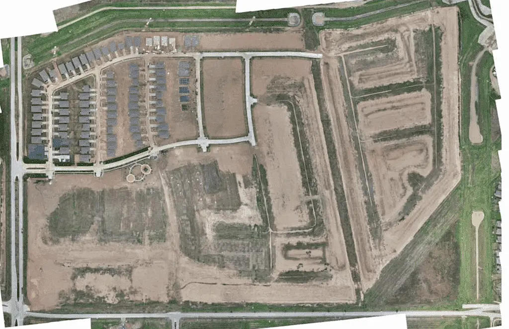
Drone mapping is a strong fit for large sites, repeatable progress documentation, preconstruction baselines, volumetric analysis, corridor overview, and hard-to-access terrain. It is especially effective when teams need broad site visibility without slowing field operations.
It is not a universal replacement for conventional surveying. Boundary work, legal descriptions, monumentation, and certain highly constrained site conditions still require traditional methods or direct oversight from licensed survey professionals, depending on scope and jurisdiction. Dense canopy, reflective surfaces, active traffic, tight vertical obstructions, and poor GPS environments can also affect results.
That does not make drone mapping less valuable. It simply means the right workflow depends on the decision being made. In many commercial settings, the best outcome comes from combining drone data with existing control, field verification, and project-specific survey requirements.
What affects accuracy in survey grade drone mapping
Accuracy starts before the drone leaves the ground. Mission design has to account for altitude, overlap, lighting, surface texture, and the level of detail required. A site intended for basic visual documentation does not need the same planning discipline as a site where elevation change and material movement are being measured.
Control is another major factor. RTK and PPK-enabled workflows improve positional performance, but they do not automatically eliminate the need for well-placed control and checkpoints. That is where many assumptions break down. A drone with advanced positioning can support a highly accurate mapping job, but the final result still depends on site conditions, control strategy, and validation.
Processing quality also matters more than many buyers realize. Photogrammetry software can generate large datasets quickly, but speed is not the same as reliability. Misaligned images, weak tie points, poor ground classification, or incorrect coordinate handling can introduce errors that become a problem later, especially when datasets are compared over time.
This is why experienced commercial operators focus on deliverables, not just flight time. The value is in the finished dataset and how well it performs inside planning, engineering, and reporting workflows.
Deliverables that teams actually use
The most useful outputs from a survey-grade mapping mission depend on the project, but they should always serve a clear operational purpose. Orthomosaics help teams document current site conditions at a high level. Digital surface models and contour maps support grading review and drainage analysis. Point clouds provide dense spatial detail for design coordination and measurement. Volume calculations help quantify stockpiles, excavation progress, and earthwork movement.
For many clients, consistency matters as much as raw accuracy. A one-time map can answer a specific question. Repeated mapping with the same control framework, flight standards, and reporting structure creates a far more valuable record. That is how drone data becomes part of project oversight instead of a one-off deliverable sitting in a folder.
Construction teams often use recurring maps to compare schedule progress, verify subcontractor work, and track site changes between pay applications. Energy and industrial operators may use them to document asset conditions, support maintenance planning, and monitor large properties that are difficult to inspect on foot. Commercial real estate stakeholders may use them to establish site baselines before development, redevelopment, or claims review.
What buyers should ask before hiring a provider
If a provider says they offer survey grade drone mapping, the right follow-up is not whether they own a capable drone. It is how they control the job, validate accuracy, and structure deliverables for decision-making.
Ask how ground control or checkpoints will be handled. Ask what coordinate system and vertical datum will be used. Ask whether outputs are intended for visual reference, planning support, or engineering-ready use. Ask how repeat missions are standardized. If the answer stays vague, the workflow probably is too.
It is also worth asking how the provider operates in live commercial environments. Active construction sites, industrial facilities, and infrastructure corridors require more than flight skill. They require planning around access, safety, airspace, schedule constraints, and the realities of field operations. Fast deployment is valuable, but only if the resulting data is dependable.
That is the difference between a media vendor and a commercial drone partner. One captures images. The other delivers usable project data.
Why the workflow matters as much as the hardware
There is a tendency to reduce drone mapping to equipment specs, but hardware is only one part of the result. The stronger differentiator is workflow discipline. Consistent capture methods, site-specific planning, control validation, careful processing, and practical reporting are what turn aerial imagery into decision-grade data.
That matters even more on repeat assignments. If you are tracking a 200-acre site over several months, small inconsistencies in flight path, overlap, timing, or processing assumptions can make trend analysis less reliable. Standardized workflows protect the integrity of the record.
For companies managing complex assets across Texas, that reliability can directly reduce field time and improve coordination between owners, engineers, contractors, and operations teams. It shortens the gap between conditions in the field and decisions in the office.
At Drone Services Texas, that is the point of the service. Not generic footage, and not mapping that stops at a pretty deliverable. The objective is usable, engineering-ready output that supports work already in motion.
When survey-grade mapping is done right, it gives teams a clearer picture of the site without adding friction to the job. That is usually the real win – fewer assumptions, faster validation, and data people can act on with confidence.