A superintendent notices the issue before the concrete crew rolls in. A haul road has shifted, a stockpile is encroaching on the staging area, and the latest ground photos do not show the full picture. This is where a construction drone orthomosaic map stops being a nice visual and starts acting like a field tool.
On active jobsites, decisions are only as good as the site data behind them. A current orthomosaic gives project teams a corrected, high-resolution top-down image of the site that can be measured, shared, and compared over time. It turns aerial capture into something operational – not just something that looks good in a progress report.
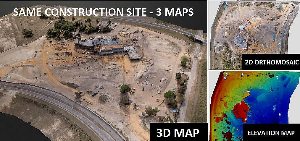
Why does a construction drone Orthomosaic map deliver ?
An orthomosaic map is built from many overlapping drone images processed into one geometrically corrected image. Unlike a standard aerial photo, it is adjusted for camera angle, terrain variation, and distortion so features appear in consistent scale. That matters when teams need to measure distances, verify site conditions, or compare changes from one flight to the next.
For construction, the real value is context. Ground photos show details, but they miss relationships across the site. A construction drone orthomosaic map shows how access roads, laydown yards, utilities, excavations, structures, and material movement relate to each other on the same date. That makes it useful for planning, documentation, dispute support, and daily coordination.
The best deliverables go beyond a stitched image. Commercial teams often need engineering-ready outputs that fit into project workflows, whether that means overlaying the map against design plans, checking grading progress, or documenting conditions before a change order discussion.
Why project teams use orthomosaic mapping on active sites
Construction sites change fast. Even on smaller projects, a week can bring enough movement to make older documentation unreliable. Orthomosaic mapping gives owners, project managers, VDC teams, and field supervisors a current visual record they can reference without sending multiple people back into the field.
That speed has practical value. If a stakeholder needs to confirm staging conditions, drainage paths, fence line placement, or the status of site work, a current map often answers the question immediately. It reduces the back-and-forth that happens when teams rely on a mix of text updates, isolated photos, and memory.
It also supports accountability. When documentation is captured consistently, the project record becomes clearer. Teams can verify when areas were cleared, where materials were stored, how access routes were maintained, and whether progress matched the reported schedule. In commercial construction, that level of documentation can be as important as the image itself.
Where a construction drone orthomosaic map adds the most value
The strongest use cases are usually tied to coordination and verification.
Before major work begins, orthomosaic mapping helps establish existing conditions. That can support preconstruction planning, site logistics, and discussions with owners, engineers, and subcontractors. On larger sites, it creates a shared reference point that keeps everyone aligned on what the site actually looked like at mobilization.
During earthwork and utility phases, the value increases. These are stages where access, grading, trenching, and stockpile movement can change daily. A fresh orthomosaic helps teams spot conflicts early, document trench locations, and review whether site conditions match the intended sequence of work. If paired with survey-grade control, it can also support more precise measurement and integration with mapping outputs.
Vertical construction benefits in a different way. Once structures begin to take shape, orthomosaics help track crane placement, temporary access, parking changes, laydown areas, and the flow of trades around the building footprint. They are especially useful on constrained urban or industrial sites where small shifts in logistics can affect safety and schedule.
For owners and developers, the map becomes a communication tool. It provides a clean, current snapshot of progress without requiring a site walk. That is useful for portfolio oversight, lender updates, and executive reporting, especially when projects are spread across multiple locations.
Accuracy depends on the mission setup
Not every orthomosaic is suitable for construction decisions. The output depends on flight planning, overlap, altitude, lighting conditions, control points, processing methods, and the experience of the flight team. If the mission is treated like a simple media flight, the result may look sharp but still lack the positional reliability needed for field use.
That is why requirements should be defined up front. Some projects only need visual progress documentation. Others need higher accuracy to support engineering review, quantity checks, or alignment against CAD and GIS data. Those are different scopes, and the workflow should match the intended use.
Site conditions also matter. Tall structures, reflective surfaces, active equipment, and limited airspace can all affect collection quality. On some sites, frequent flights at moderate altitude produce better operational results than less frequent flights aimed at maximizing coverage. The right answer depends on site size, pace of change, and what the client needs to decide from the data.
Orthomosaic maps are most effective when they fit the workflow
A common mistake is treating drone mapping as a standalone product. On a busy project, it works better as part of a reporting and oversight process. The orthomosaic should help answer active questions, not sit in a folder unused.
That means thinking about who will use it. Superintendents may use it to review access and staging. Project managers may compare progress over time. Engineers may reference it against site plans. Owners may use it for remote visibility and recordkeeping. The same map can serve all of those functions, but only if it is delivered in a usable format and captured on a schedule that matches the project rhythm.
This is where a commercial drone partner matters. The goal is not simply to fly a site. The goal is to produce decision-grade data that fits real construction workflows, with reliable turnaround and a clear understanding of what the project team needs from each mission.
What to ask before ordering a construction drone orthomosaic map
If you are evaluating providers, start with the deliverable and work backward. Ask how the map will be used, what level of accuracy is realistic, how frequently the site should be captured, and whether control points or checkpoints are required. Clarify file formats, turnaround time, and whether the output is intended for visual reference or engineering use.
It is also worth asking how the team handles active jobsites. Construction environments are not controlled settings. Flight crews need to coordinate with site contacts, understand operating constraints, and work safely around equipment, personnel, and changing conditions. Fast deployment is useful, but only if the operation is disciplined.
For projects in regulated or complex environments, FAA compliance and operational planning are not side issues. They directly affect whether data can be collected when the project actually needs it. That is especially relevant near urban corridors, industrial facilities, or infrastructure assets where flight restrictions and site access can complicate scheduling.
The bigger value is better site decisions
A construction drone orthomosaic map is often introduced as a documentation tool, but its bigger role is decision support. It helps teams see the site clearly, confirm conditions without delay, and maintain a reliable visual record as work progresses. That reduces uncertainty, which is one of the most expensive problems on any project.
The most useful aerial data is not the most cinematic. It is the data that arrives on time, aligns with field conditions, and gives project teams something they can act on. For contractors, engineers, and owners managing active sites, that is where orthomosaic mapping earns its place.
If your project depends on current site visibility, ask for deliverables that are built for operations, not just presentation. The difference shows up quickly once the map starts answering real jobsite questions.