default
A tank battery is losing product, a compressor station needs verification, or a flare system has become a question mark instead of a known condition. In those situations, speed matters, but so does proof. An optical gas imaging drone gives operators a faster way to locate suspected emissions across large, complex sites without sending crews into every high-risk area first.
For commercial and industrial teams, the value is not the drone by itself. The value is what the deployment produces – visual confirmation of gas movement, clearer prioritization for maintenance, and inspection data that supports field decisions. When emissions, safety exposure, and downtime all carry real cost, that shift matters.
What an optical gas imaging drone actually does
An optical gas imaging drone combines a UAV platform with a specialized thermal or infrared payload designed to visualize certain gas emissions that are invisible to the naked eye. When deployed correctly, the system can help identify hydrocarbon leaks, methane emissions, and other fugitive gas releases depending on the sensor, environmental conditions, and site setup.
That last part matters. Optical gas imaging is not magic, and it is not a blanket replacement for every leak detection method. Performance depends on gas type, concentration, temperature differential, background contrast, wind, standoff distance, and operator skill. A credible provider does not oversell certainty where conditions limit detection.
What the technology does well is compress inspection time across assets that would otherwise require more labor, more access coordination, and more worker exposure. Elevated piping, storage infrastructure, process equipment, and difficult-to-reach components can be screened quickly from the air, then escalated for ground verification or repair planning when needed.
Why operators are using optical gas imaging drone services
For most commercial clients, the decision is operational before it is technical. They are not looking for interesting footage. They need usable evidence that helps them respond faster and document what they found.
In oil and gas, chemical processing, midstream, and industrial environments, conventional inspections can be slow and disruptive. Walking every asset is time intensive. Lifts and rope access increase coordination and safety burden. Some areas may be difficult to access during active operations, while others may require shutdown considerations that operators want to avoid unless there is a clear reason.
An optical gas imaging drone can shorten that cycle. Instead of treating the whole facility as equally urgent, teams can focus attention where the imagery suggests active release or abnormal conditions. That means maintenance crews spend more time fixing prioritized issues and less time searching blindly across an entire site.
The other driver is compliance pressure. Many operators need better documentation around emissions monitoring, internal inspection programs, and environmental stewardship. Aerial optical gas imaging supports that effort by adding a time-stamped visual record to the inspection workflow. It does not replace a compliance program on its own, but it can strengthen the quality and speed of the data feeding that program.
Where aerial gas imaging makes the biggest difference
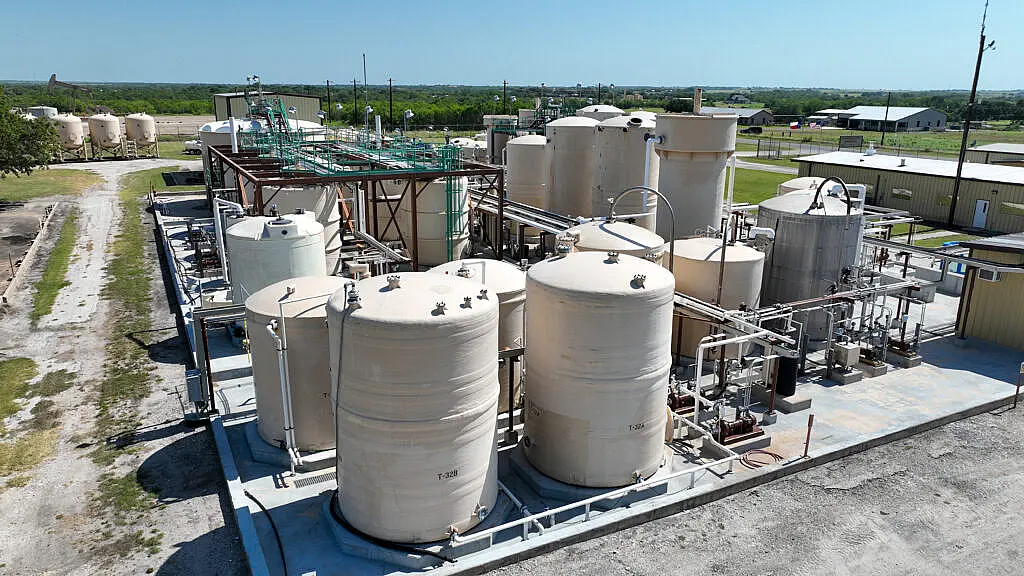
The strongest use cases are sites where scale, access difficulty, and operational sensitivity create friction for traditional inspections. Tank farms are a common example because valves, hatches, seals, and associated equipment can be spread across a wide area. Gathering a fast visual scan from the air helps teams identify where closer follow-up is warranted.
Compressor stations and processing facilities also benefit because leak sources may exist around elevated or congested equipment. Aerial deployment can reduce the need to immediately place personnel near active equipment while still giving operators a strong first look at potential problem areas.
Pipeline and midstream assets present another practical application. Not every segment is suitable for the same approach, but stations, above-ground components, and accessible corridor assets often benefit from drone-based screening. Large industrial campuses, refineries, and utility infrastructure can see similar gains when site access and inspection speed are limiting factors.
This is also where local operating experience matters. In Texas, for example, wind, heat load, and complex industrial layouts can affect both flight planning and sensor performance. Providers that regularly work around active energy and infrastructure assets are better equipped to plan around those variables instead of reacting to them in the field.
What good deliverables look like
The difference between a basic flight and a useful inspection is the deliverable. Commercial teams need output they can hand to operations, maintenance, EH&S, engineering, or asset management without translation.
That usually means more than raw video. A strong optical gas imaging scope should include organized findings, annotated visuals where appropriate, location references, flight documentation, and a clear record of observed conditions. Depending on the mission, clients may also need conventional visual imagery, thermal context, or a combined reporting package that ties gas observations to specific assets.
Decision-grade data is the real benchmark. If the result does not help a site team determine what to inspect next, what to repair first, or what to document for internal review, the deployment has limited value no matter how advanced the sensor was.
Limits, trade-offs, and what clients should ask
This is specialized work, and buyers should expect honest discussion about constraints. Not every gas is detectable with the same camera. Not every leak rate will present clearly from every angle. Wind can disperse plumes. Poor thermal contrast can reduce visibility. Congested backgrounds can complicate interpretation.
That does not make the method unreliable. It means mission planning matters. Operators should ask what gases the payload is suited to detect, how weather affects collection, what stand-off distances are realistic, and what level of confidence can be assigned to the findings. They should also ask how the provider distinguishes between a screening mission and a confirmatory inspection.
Flight authorization and safety planning matter too. Industrial and energy sites often involve airspace constraints, active operations, electromagnetic interference considerations, and sensitive safety requirements. The provider should be able to explain how they handle FAA compliance, site coordination, risk mitigation, and operational documentation.
A mature service partner will talk about the inspection in terms of outcomes, not gadget specs. The right conversation is about asset coverage, probable detection conditions, reporting needs, and how the data will fit into your existing maintenance or compliance workflow.
Optical gas imaging drone work is only as good as the operation behind it
The sensor gets attention, but execution is what determines whether the job creates value. Gas imaging missions require disciplined flight operations, experienced visual interpretation, and a clear understanding of industrial environments. A provider working in an active facility has to coordinate around people, equipment, schedule pressure, and safety controls without slowing the site down.
That is why commercial buyers tend to favor service partners with inspection experience rather than general aerial media backgrounds. The job is not to collect attractive imagery. The job is to gather usable high-accuracy precision data under real site conditions and return it in a format the client can act on quickly.
For companies evaluating partners, responsiveness is not a small detail. Suspected emissions events, compliance needs, and outage-related inspections often move on short timelines. Fast deployment only helps if it is matched by disciplined field execution and reporting that supports immediate next steps.
Teams that need this kind of support can learn more about operational drone inspection capabilities at Drone Services Texas, where the focus stays on engineering-ready deliverables and field-useful results rather than generic footage.
When an optical gas imaging drone is the right choice
The right fit is usually clear when there is a need to inspect a large area quickly, reduce personnel exposure, verify suspected emissions, or add stronger visual documentation to an existing inspection program. It is especially effective when the cost of delayed detection is higher than the cost of rapid aerial deployment.
It may be less effective as a stand-alone answer when site conditions are poor for gas visualization or when a client expects one flight to replace every other inspection method. In practice, the best results often come from combining aerial screening with targeted ground follow-up. The drone helps narrow the search, document the condition, and speed up the maintenance decision.
That is the practical standard commercial teams should use. Not whether the technology sounds advanced, but whether it reduces field time, lowers exposure, improves visibility across hard-to-access assets, and delivers evidence your team can use the same day.
For operators managing large facilities, emissions risk, or complex inspection schedules, that kind of clarity is not a nice extra. It is what keeps small problems from becoming expensive ones.