

A contractor wants a monthly view of a 40-acre site without paying a crew to walk it. A commercial broker needs photos that show a warehouse’s yard, access roads, and the highway nearby. An engineer wants a current elevation model before grading starts. All three are asking for “drone services,” but they need very different things.
This guide explains what drone aerial photography services actually are, how they work, and where photography ends and mapping begins. It also covers how drone surveys help construction projects, which industries use them, what they cost in 2026, and how to choose a provider you can trust. Along the way, it flags a few Texas-specific rules that buyers often miss.
Quick Takeaways
- Drone aerial photography captures images and video for marketing, documentation, and visual inspection. Drone mapping produces measurable, georeferenced data like orthomosaics and elevation models.
- A pretty photo isn’t measurable data. If you need to measure distances, areas, or volumes, ask for mapping deliverables and a stated accuracy.
- In Texas, legal boundary and stamped survey work must be done by a Registered Professional Land Surveyor (RPLS). Drone data can support a survey, but a pilot alone shouldn’t sell you a “survey.”
- Anyone flying a drone for business in the U.S. needs an FAA Part 107 Remote Pilot Certificate, and the aircraft must comply with Remote ID.
- Pricing depends on the deliverable, not just flight time. Ask what you’ll receive, in what format, and at what accuracy.
What Are Drone Aerial Photography Services?
Drone aerial photography services are professional services in which a certified pilot uses a camera-equipped drone to capture still images, video, or data from the air, and delivers finished results to a client. “Professional” matters here. It means the flight is planned, legal, insured, and produces something useful at the end, not just a few clips.
The term covers a range of work:
- Aerial photos and video for real estate, marketing, and project documentation
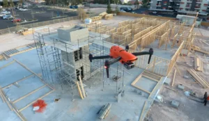
- Progress documentation of construction sites over time
- Inspections of roofs, structures, and equipment
- Mapping that turns overlapping photos into measurable maps and 3D models
- Specialty sensors such as thermal cameras or LiDAR, depending on the provider
Providers usually list these under different names: aerial photography, drone photography, commercial drone services, drone mapping, or drone surveying. The labels overlap, which is why it’s worth asking exactly what you’ll receive.

Drone Aerial Photography Services in Austin
How Does Drone Aerial Photography Work?
The basic process is straightforward, though a lot happens behind the scenes.
- Scoping. You explain what you need: the site, the purpose, the deliverables, and the deadline. A good provider asks questions about accuracy, file formats, and who will use the results.
- Planning and compliance. The pilot checks the site, weather, and airspace. Near airports or in controlled airspace, the pilot needs FAA authorization, often through LAANC, an automated system that can return approvals quickly. They also check property access and permissions, and whether any restricted areas are involved.
- Flight. For photography, the pilot flies manually or along set shots, choosing altitude, angle, and light. For mapping, the drone usually flies a pre-programmed grid that captures overlapping images. One drone-mapping guide cites an overlap of roughly 70 percent front and 60 percent side as a common setup.
- Capture. The drone records images or video, often with GPS data attached to each frame. For higher-accuracy mapping, pilots may add ground control points, or use RTK or PPK positioning, which correct GPS data.
- Processing and editing. Photos get color-corrected and edited. Mapping data goes through photogrammetry software, which stitches images into maps and models.
- Delivery. You receive files through a download link, cloud platform, or web viewer, sometimes with a short report.
The main difference between photography and mapping is what happens in steps 3 through 5. Photography is about composition and light. Mapping is about coverage, overlap, and positional accuracy.
What Types of Aerial Photos Can Drones Capture?
| Type | What It Shows | Common Uses |
| Overview shots | A wide view of a property, campus, or site | Marketing, investor updates, site context |
| Oblique angles | A three-quarter view at an angle | Real estate, showing how buildings sit on a lot |
| Top-down (nadir) images | Straight down, like a map | Site plans, roof layouts, documentation |
| Progress photos | The same viewpoints repeated over time | Construction updates, verifying work |
| Close-up detail shots | Roof edges, equipment, damage | Inspections, insurance documentation |
| Panoramas | Wide stitched views | Large sites, waterfront, developments |
| Twilight or golden-hour aerials | Softer, atmospheric light | Marketing for commercial and residential properties |
| Aerial video | Motion footage, orbits, fly-throughs | Promotion, project stories, site tours |
| Thermal images | Heat patterns, not visible light | Roof moisture, electrical, insulation, equipment |
If you’re commissioning photos for marketing, tell the provider how you’ll use them (web, print, signage), since that affects resolution, editing, and licensing.
How Are Drone Services Used for Aerial Mapping?
Drone mapping, also called aerial mapping or photogrammetry, turns overlapping photos into data you can measure. The drone flies a planned pattern, software matches points across hundreds of images, and it reconstructs the site in two or three dimensions.
Common mapping deliverables include:
- Orthomosaic map. A high-resolution, georeferenced overhead image stitched from many photos and corrected for perspective, so you can measure on it.
- Digital surface or elevation model (DSM/DEM). A grid of elevation values for the site.
- Contours and topographic maps. Elevation lines derived from the model, used in planning and engineering.
- Point cloud. A dense set of 3D points representing surfaces.
- 3D model or mesh. A visual reconstruction for review and presentations.
- Volumetrics. Calculated volumes for stockpiles or excavations, and cut and fill comparisons.
- Progress comparisons. Overlays of new data against earlier flights.
About accuracy. It depends on the equipment, the method, and how the data is checked. One 2026 industry guide says that with RTK or PPK positioning and real check points, drone mapping can reach roughly 1 to 3 centimeters horizontally and 2 to 5 centimeters vertically, and that accuracy is only meter-level without them. Those are best-case figures from one source, not promises. Ask any provider what accuracy they expect on your project and how they verify it.
What Is the Difference Between Drone Photography and Aerial Mapping?
They use the same aircraft, but they solve different problems.
| Drone Photography | Aerial Mapping | |
| Main goal | A compelling or informative image | Measurable, georeferenced data |
| Flight style | Creative, manual, or planned shots | Automated grid with set overlap |
| What you receive | Edited photos and video | Orthomosaics, elevation models, point clouds, volumes |
| Measurable? | Not reliably | Yes, within a stated accuracy |
| Accuracy needs | Usually none | Defined, often with ground control or RTK/PPK |
| Typical buyers | Real estate, marketing, developers | Engineers, contractors, planners |
| Cost driver | Time, editing, shots | Area, accuracy, and processing |
A simple test: if you’ll ever need to measure something off the image, like a distance, area, slope, or pile volume, you need mapping, not just photography. Photos that look accurate aren’t necessarily to scale.
How Do Drone Surveys Help Construction Projects?
Construction is one of the biggest uses of drone data, because sites change constantly and the people who need to see them are often somewhere else.
Before construction
- Existing conditions and topography. A current terrain model helps engineers plan grading, drainage, and layout.
- Site planning and logistics. Aerial views help teams plan access, laydown areas, and staging.
During construction
- Progress documentation. Regular flights show what’s been built, compared with the plan and the last visit.
- Earthwork and volumes. Cut and fill comparisons and stockpile volumes help with quantities and billing.
- Verifying contractor work. Owners and lenders can review progress without walking every acre.
- Safety and site awareness. Aerial views can spot access, traffic, or storage issues.
- Stakeholder updates. Clear visuals for investors, owners, and city staff.
After construction
- Documentation of finished conditions. A record of the site as completed.
- Roof and facade review. Visual and thermal inspection in some cases.
Benefits in plain terms
Faster site data than walking a large site, fewer people in hazardous areas, repeatable results you can compare month to month, and visuals everyone can understand.
Limits worth knowing
Drone data doesn’t replace every kind of ground survey. Vegetation can hide the ground from a camera, and weather can delay flights. Legal boundary work and construction staking are separate jobs. Which brings up an important point.
A Note on the Word “Survey” in Texas
In Texas, surveying is a regulated profession. According to the Texas Board of Professional Engineers and Land Surveyors, only duly licensed and registered persons may legally perform, or offer to perform, engineering or surveying services for the public. Professional land surveying, including boundary work, is defined in the Texas Occupations Code (Chapter 1071).
What that means for buyers:
- Drone mapping (orthomosaics, elevation models, progress data) is widely used by engineers and contractors, often as input to design work.
- Boundary surveys, legal descriptions, and stamped survey products need a Registered Professional Land Surveyor (RPLS).
- Be cautious about claims like “survey-grade” or “drone surveying” from a company that doesn’t include a licensed surveyor or engineer in the process. Ask who is responsible for the accuracy and who signs off if you need a stamped deliverable.
If you’re unsure, ask the Texas board or your attorney what your project requires.
What Industries Use Commercial Drone Services?
| Industry | Common Uses |
| Construction and development | Progress documentation, site mapping, volumetrics, verification |
| Commercial real estate | Property marketing, investor visuals, site context, portfolio documentation |
| Residential real estate | Listing photos and video |
| Energy, oil and gas | Facility and pipeline corridor documentation, inspections, thermal and gas detection (with specialist providers) |
| Engineering and land development | Topographic base data, planning support, corridor mapping |
| Roofing and insurance | Roof documentation, storm damage review |
| Agriculture | Crop health imaging and field mapping |
| Utilities and infrastructure | Asset inspection, right-of-way mapping |
| Solar and renewables | Site planning, thermal inspection of panels |
| Mining and aggregates | Stockpile volumes, terrain models |
| Environmental and public safety | Habitat monitoring, disaster documentation |
| Data centers and industrial facilities | Roof and equipment inspection, progress documentation |
| Marketing and events | Aerial promotional images and video |
Texas has an unusually strong mix of construction, energy, and industrial work, which is why so many providers here cover both photography and mapping.
How Much Do Drone Aerial Photography Services Cost?
Prices vary by provider, region, and deliverable. These ranges come from published 2026 pricing guides and providers’ own pages, and they’re ballparks, not quotes.
| Service | Typical Range (2026 Published Guides) | Notes |
| Aerial photography (hourly) | Roughly $150 to $400 per hour | Some guides go higher for commercial work |
| Residential real estate package | Roughly $250 to $500 | One Southwest provider’s example for 15 to 20 photos and a short video |
| Commercial property shoot | From about $800 | Larger parcels, twilight shots, or tenant views |
| Construction progress visit | Roughly $500 to $2,200 per visit | Depends on site size and deliverables |
| Monthly progress package | Roughly $1,000 to $3,000 per month | Recurring visits with maps or reports |
| Basic mapping (orthomosaic) | Roughly $5 to $30 per acre | Guides vary. Small sites often have minimum fees |
| Small mapping project (under 50 acres) | Roughly $500 to $2,500 | Varies with accuracy and deliverables |
| Medium mapping project (50 to 500 acres) | Roughly $2,500 to $10,000 | Larger or more precise work costs more |
| Thermal or LiDAR | Roughly $300 to $700 per hour, or a minimum project fee | Specialty equipment |
A few sources listed much higher per-acre figures (for example, $200 to $500 per acre for some engineering-grade work), which shows how wide the range is. The takeaway is that the deliverable and accuracy matter more than the hour count.
What affects the price
- Site size and complexity
- Deliverables (photos only vs. maps, models, volumes, reports)
- Accuracy (ground control, RTK/PPK, check points)
- Processing time
- Turnaround
- Airspace or access complications
- Travel and mobilization
- Repeat visits (recurring work is often discounted)
- Insurance and compliance overhead
Questions to ask for an accurate quote
- What exactly will I receive, and in what format?
- What accuracy do you expect, and how is it verified?
- Is processing included?
- Are there minimums, travel fees, or rush fees?
- How many flights or revisions are included?
- How are usage rights handled?
How to Choose the Right Drone Service Provider
Start with your goal, then match the provider. Here’s a way to think it through.
Decide what you need the data for
- Marketing or visual documentation? A photography-focused provider may be enough.
- Measurements, planning, or engineering input? Look for a provider with mapping experience and, where needed, engineering or licensed-surveyor involvement.
- Inspection or specialty data? Ask about thermal, LiDAR, or specialty sensors.
Match the provider’s experience to your industry
A provider who understands construction schedules, oil and gas sites, or commercial real estate marketing will ask better questions and deliver more useful results.
Look at examples relevant to your project. A strong real estate portfolio doesn’t prove mapping skill, and vice versa.
Consider the whole workflow. Who processes the data? Who checks it? Who delivers it, and in what format? A provider that hands over raw files may not help if your team needs CAD-ready or GIS-ready outputs.
Think about recurring needs. If you need monthly progress data, ask about consistent flight paths, repeatable methods, and a subscription or retainer.
Compare responsiveness and clarity. How quickly do they respond? Do they explain deliverables plainly? Can they scope a project without jargon?
Compare quotes on the same basis. Two quotes can look different because they include different deliverables, accuracy, or processing.
What Should You Look for Before Hiring a Drone Photography Service?
Here’s a checklist to run through before you sign.
Credentials and compliance
- FAA Part 107 Remote Pilot Certificate. Required for commercial flights in the U.S. It’s issued to individuals, so every pilot flying your job should hold one. Ask to see it.
- Aircraft registration and Remote ID. Commercial drones must be registered, and most must broadcast Remote ID.
- Airspace authorization. Ask how they handle controlled airspace, especially near airports.
- Waivers if needed. Some operations, like flying over people or beyond visual line of sight, need special FAA approval.
Insurance
- Aviation liability insurance. Many professional clients expect one million dollars or more in coverage, and standard business or photography policies often exclude drones. Ask for a certificate of insurance and check what it covers.
Texas-specific issues
- Privacy law. Texas Government Code Chapter 423 restricts using a drone to capture images of individuals or private property with the intent to conduct surveillance, and it lists many lawful purposes. A good provider understands where their work falls and gets permission for private property.
- Restricted sites. Texas law also restricts low flights over certain critical infrastructure and other facilities. If your project involves energy or industrial facilities, ask how the provider handles access and authorization.
- Survey claims. As covered above, watch for “survey” language without licensed involvement.
Quality and process
- Examples of similar work, with real deliverables, not only highlight reels.
- A written scope. Deliverables, file formats, accuracy, timeline, and price.
- Data handling. Where files are stored, how long, and who owns them.
- Usage rights. Can you use the images commercially and share them?
- Redundancy. What happens if weather or equipment delays the flight?
Communication
- A clear point of contact, realistic timelines, and plain-language answers.
Red flags: no proof of certification or insurance, vague deliverables, unclear accuracy claims, an unusually low quote, or promises of “survey-grade” results with no licensed professional involved.
Professional Drone Services of Texas, for example, lists aerial photography, photogrammetry, aerial survey, thermal imaging, and construction and industrial services across several Texas cities on its website. Whichever provider you consider, ask for the checklist items above in writing.
Frequently Asked Questions
Do I need to be present during the flight?
Usually not, but you’ll need to arrange site access and safety contacts. For active job sites, coordinate with the site manager.
How long does it take to get the results?
Photos and videos are often delivered within days. Mapping projects can take longer because of processing and quality checks. Ask for a timeline in writing.
Can drones fly in bad weather?
Wind, rain, low clouds, and poor visibility can delay flights. Good providers build in flexibility, especially for outdoor deadlines.
Can I use the photos for marketing?
Usually, but confirm the usage rights in your agreement. Some providers license images for specific uses.
Do drone maps replace a boundary survey?
No. Drone mapping can support planning and design, but legal boundary work in Texas requires a Registered Professional Land Surveyor.
Are thermal and LiDAR the same as regular mapping?
No. Thermal shows heat patterns, and LiDAR uses laser pulses to build terrain and structure data, which can be helpful under vegetation. They use different sensors and cost more.
Will the provider need access to private property?
Often yes. Get the property owner’s permission, and ask how the provider handles privacy and notice.
How often should a construction site be flown?
It depends on the project. Many teams use weekly, biweekly, or monthly flights, and add extra flights around key milestones like grading or foundations.