

A missing roof unit, an outdated tank count, a transmission structure logged in the wrong location – small inventory errors turn into expensive field time fast. Drone asset inventory management helps commercial teams document what exists, where it sits, and what condition it is in without relying on fragmented site walks, stale spreadsheets, or incomplete photo sets.
For construction, energy, infrastructure, and industrial operators, the value is not the aircraft itself. The value is a current, verifiable record of assets tied to usable imagery, measurable location data, and repeatable capture methods. When inventory management is handled with drone-based data collection, teams can move from rough counts and manual notes to a system that supports maintenance planning, compliance documentation, capital forecasting, and dispute reduction.
What drone asset inventory management actually means
At the operational level, drone asset inventory management is the process of using aerial data capture to identify, count, locate, classify, and visually document physical assets across a site or portfolio. That can include rooftops, utility infrastructure, process equipment, storage tanks, solar arrays, laydown yards, pipelines, stormwater assets, construction materials, and large commercial properties.
The key difference between basic aerial photography and a real inventory workflow is structure. A useful inventory program is designed around asset IDs, repeatable capture angles, mapped positions, condition visibility, and deliverables that can be handed to project managers, engineers, facility teams, or compliance personnel. If the output is only a folder of photos, it is not solving the core problem.
That distinction matters because most asset owners are not struggling to collect more images. They are struggling to keep asset records current, searchable, and defensible when someone asks for proof in the field or in a meeting.
Why manual inventories break down
Manual inventory collection still has a place, especially when teams need tactile verification, serial number checks, or close-access review. But across large, active, or hard-to-reach sites, the process tends to drift. Different crews document assets differently. Photos are taken without consistent orientation. Counts are recorded on one platform while location details live somewhere else. By the time the information is compiled, part of it is already outdated.
That problem grows on projects with continuous change. Construction sites add, move, or remove materials and equipment weekly. Energy and industrial facilities may have assets spread across broad footprints with access constraints, safety restrictions, or downtime limitations. Commercial real estate portfolios often need current property condition visibility without disrupting tenants or site operations.
Drone-based capture does not eliminate every inventory challenge, but it reduces several of the biggest ones. It shortens field collection time, improves visual consistency, and creates a clearer chain between the asset and the documentation attached to it.
Where drone asset inventory management delivers the most value
The strongest use cases are the ones where scale, visibility, and repeatability matter more than close-hand inspection alone. Large rooftops are a good example. A drone can document HVAC units, skylights, drains, solar equipment, and visible membrane conditions far faster than a traditional walk, while also producing an overhead context that helps teams understand distribution and access.
In construction, drone asset inventory management helps teams track stored materials, installed components, heavy equipment staging, temporary infrastructure, and site progress. It is especially useful when owners or general contractors need a visual record tied to a specific date for procurement checks, pay application support, or schedule coordination.
For infrastructure and utilities, the value often comes from location accuracy and network visibility. Poles, towers, substations, culverts, channels, and right-of-way assets can be documented in a way that supports planning and prioritization. In industrial settings, aerial inventory can support tank farms, flare systems, pipe racks, perimeter assets, and elevated structures where access is time-consuming or introduces added safety planning.
There is a trade-off, though. If the objective is to read fine equipment labels under heavy shadow or inspect concealed defects, the drone mission may need to be paired with ground verification or other inspection methods. The right program is not about replacing every field task. It is about assigning the drone to the parts of inventory work where it creates the clearest operational gain.
What good deliverables look like
A commercial buyer should expect more than attractive visuals. The most useful deliverables for drone asset inventory management are organized around action.
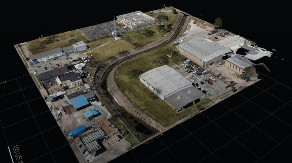
That usually means georeferenced imagery, orthomosaic maps, asset-specific photo documentation, annotated observations, and a naming structure that aligns with the client’s existing asset register or project workflow. In some cases, teams also need volumetric context, measurement support, thermal overlays, or recurring capture intervals for change tracking.
The level of precision should match the business use case. A marketing team may only need current aerial references for portfolio visibility. An engineering or facility team may need higher positional accuracy and more disciplined documentation standards. A compliance-driven project may require date-stamped records, repeat capture methodology, and outputs that can be reviewed alongside inspection logs or environmental reports.
This is where service quality shows up quickly. If a provider understands asset management, the deliverables are structured to be used by operations teams, not just viewed once and archived.
Building a drone asset inventory management workflow
The most effective programs start with scope discipline. Before the first flight, the operator and client should define which asset classes matter, what level of visibility is required, how assets will be labeled, and where the final data needs to go. That sounds basic, but it prevents one of the most common failures in inventory projects: collecting a large amount of imagery that cannot be sorted into a usable record.
Flight planning comes next. Capture altitude, angle, overlap, and timing all affect what can be identified later. A roof inventory may require nadir mapping plus oblique views for equipment condition context. A tank farm or substation may need multiple perspectives to separate adjacent assets cleanly. Weather and site activity also matter. Harsh glare, parked vehicles, active lifts, or temporary obstructions can limit the usefulness of a data set if the mission is not timed well.
After collection, processing and QA are where the inventory becomes dependable. Assets must be matched correctly, duplicate records removed, labels standardized, and visibility gaps flagged. For recurring programs, consistency across visits is just as important as image quality on a single day. If the angle, coverage, or naming convention changes every month, trend analysis becomes harder than it should be.
The role of accuracy, compliance, and safety
Commercial clients usually ask the same practical question: how accurate is this, and can we rely on it? The honest answer is that it depends on the capture method, site conditions, and intended use. Not every inventory project requires survey-grade outputs. But when decisions involve engineering, compliance, or capital planning, the tolerance for vague documentation drops fast.
That is why professional drone operations matter. FAA-compliant flight execution, airspace planning, site-specific safety coordination, and repeatable data capture are not side issues. They directly affect whether the final inventory can support business decisions without adding risk. On active industrial and infrastructure sites, safety planning is part of data quality.
Compliance is another reason companies adopt aerial inventory workflows. Current visual records can support environmental documentation, maintenance history, insurer communications, and owner reporting. They are also useful when there is disagreement over asset condition, installation status, or change over time. A dated aerial record with clear positional context is often more useful than a written note without visual proof.
Choosing a provider for drone asset inventory management
The right provider should understand the operating environment first and the flight second. That means asking how the inventory will be used, who needs the outputs, what level of accuracy matters, and how often updates are required. A provider focused only on collecting footage may miss the asset logic that makes the work valuable.
Look for evidence of experience in commercial and industrial settings, not just general drone operations. Construction sites, utility corridors, energy facilities, and occupied commercial properties all come with different constraints. Deliverables should also reflect business use. If you need decision-grade data for field operations or project oversight, the workflow must be built around those outcomes.
This is where a specialized commercial partner such as Drone Services Texas brings real value. The difference is not simply flight capability. It is the ability to turn aerial collection into engineering-ready, operations-ready documentation that reduces field guesswork and gives stakeholders a current record they can act on.
A well-built inventory program gives teams a more stable operating picture. When assets are documented clearly and updated on a repeatable schedule, decisions get faster, site visits get more targeted, and fewer questions are left to memory. That is usually the point where drone data stops being interesting and starts being useful.